GEOCLIP USE CASE:
THE FRENCH “REGIONAL HEALTH AGENCIES” (ARS’) C@RTOSANTÉ OBSERVATORY


⟫ Download the Géoclip case study - The French “regional health agencies” (PDF)


The French “regional health agencies” (ARS) are responsible for the regional management of the health system in France. They define and implement health policy in the French regions as closely as possible to the needs of the population. The French regional health agencies are carrying out various information dissemination projects, including “C@rtoSanté”, through their geographic portal “AtlaSanté”; these projects aim to support health professionals, territorial decision-makers, researchers, etc. in their decisions in the field of public health.

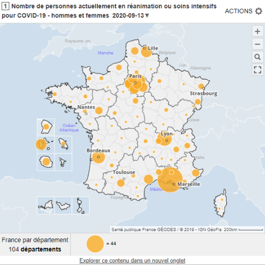
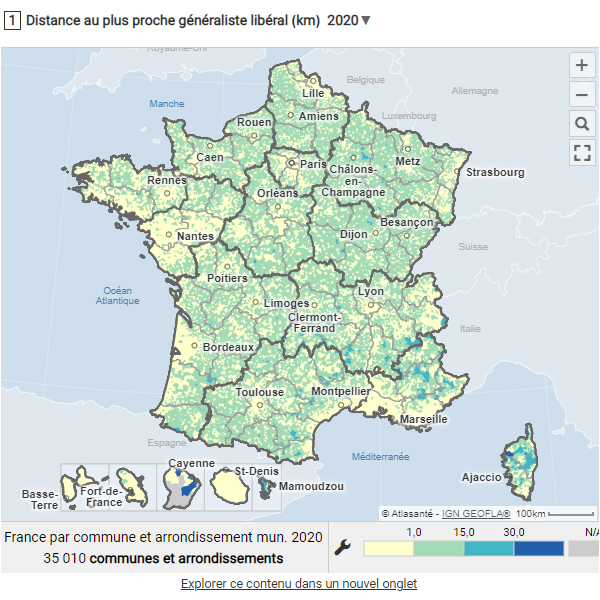
The geostatistical observatory “C@rtoSanté”, based on Géoclip since 2004, is one of the historical ARS projects dedicated to medical demography, demand and access to care for private primary care health professionals - general practitioners, nurses, massage therapists, physiotherapists, dental surgeons, speech therapists and midwives.


Read more

Géoclip 4.12.0 is available

GÉOCLIP 4.12.0 IS AVAILABLE


» Discover the new features of Géoclip 4.12.0!


Géoclip 4.12.0 is available


Géoclip, Ciril GROUP's web-based GIS solution for geostatistical observatories, is regularly enriched to offer still more effective and differentiating features. Géoclip unveils its new version 4.12.0 to offer users and administrators new features on the TJS protocol side as well as improvements related to security, administration, the user interface, etc. for observatories.


Géoclip promotes shared knowledge of territories through the accessibility and exchange of statistical data, as evidenced by the TJS - Table Joining Service - exchange format, one of Géoclip's key assets. The TJS protocol of the Open Geospatial Consortium (OGC) promotes interoperability and enables several databases to be connected to each other by means of web services in order to facilitate the sharing of geolocated data sets and/or indicators between observatories based on the Géoclip solution.


Read more

Géoclip - Télécoms - Fibre optique FTTH

DEMONSTRATION GEOCLIP :
Observatoire du déploiement de la fibre optique FTTH

Découvrez l’observatoire du déploiement de la fibre optique : telecoms.geoclip.fr.  

Cette démonstration Géoclip a été créée par les équipes de Business Geografic en vue de proposer un observatoire géostatistique du déploiement de la fibre optique FTTH ("fiber to the home", fibre optique jusqu'à l'abonné) sur le territoire français.

Read more

ANCT’s Territorial Observatory has been given a new look, and uses the new Géoclip APIs

L’observatoire des Territoires (OT) de l’ANCT est le portail de référence pour l’analyse de tous les territoires en France. Il expose des indicateurs soigneusement sélectionnés, tenus à jour, et valorise les travaux d’équipes universitaires.

Il se présente aujourd’hui avec une ergonomie rénovée, qui met en avant les nombreux services pratiques proposés. C'est un public encore plus large qui est ainsi visé. Cette évolution majeure de l’OT exploite davantage encore l’intelligence apportée par Géoclip via de nouvelles APIs (fonctions qui permettent l'accès aux services d'une application externe).

Read more

GeoIgnite 2020

GeoIgnite – July 2020

GeoIgnite 2020

Ciril GROUP takes part for the second consecutive year in GeoIgnite, Canada's national GIS event; a virtual edition this year due to the current context.


In view of the global health crisis related to the Covid-19 coronavirus pandemic, GeoIgnite's team has modified the format of the event to ensure that it takes place in the best possible conditions. The theme and the program of the exhibition - "Leadership in Times of Disruption" - have been reviewed to adapt to this "videoconference" format.

Read more

Ciril GROUP’s business continuity planning

Like everyone else, people working for Géoclip are adapting to the context imposed by the Covid-19 pandemic. Our hope is that everyone will find the resources to get through this exceptional situation in the best possible conditions. Within our teams, we are making every effort to ensure that our activities continue. Naturally, we have all adopted teleworking. Modern communication techniques fortunately allow us to continue our activities remotely.

The challenge for our teams is first and foremost to help curb the pandemic. This is why significant resources are being deployed so that we can continue to work together. Secondly, it is to preserve economic activity. We are therefore committed to remaining present and active.

For example, it is a great satisfaction for us to see that the Geodes observatory, of Santé Publique France, has been publishing daily and weekly data on the evolution of the epidemic for the past few days. We are proud to contribute, at our level, to the dissemination of reliable information. We are convinced that promoting knowledge is a good way to limit the insecurity that the health crisis we are inevitably experiencing generates.

Read more

At the dawn of 2020, a 20-point overview

Au tournant de l'an, au moment où 2019 laisse la place à 2020, quels sont les éléments saillants du paysage de Géoclip ? Voici, en 20 points précisément, une photographie de la situation actuelle.

Read more

A glance in the rear view mirror

Eric Mauvière a créé Emc3 en 1999, quand il a lancé son activité personnelle en conseil et accompagnement pour la valorisation des données statistiques locales. Répondre concrètement aux besoins et attentes de ses clients en matière d’organisation de systèmes d’information et d’outils de visualisation de données statistiques est à l’origine de ce qui a conduit naturellement au développement de Géoclip (www.geoclip.fr).

Le choix précurseur à l’époque a été d’opter pour des technologies entièrement basées sur le web, pour créer des outils accessibles à tous. Les fonctionnalités des outils sont, quant à elles, basées sur l’expérience acquise à l’Insee en matière d’études et de diffusion, à partir des logiciels statistiques disponibles alors, qui permettaient pour la première fois de créer des cartes thématiques de façon automatisée. Read more